
Kaity Taylor
The population centre of the United States can essentially be defined as the average location where people in the United States currently live. The U.S. Census describes the population centre as, ‘If the United States map was a scale and every person had equal weight, the centre of population is the place where the scale would balance’. The concept of the population centre was devised in order to track the demographic movement of people throughout the States. Since the early days of the United States, the population and, by extension, the population centre have been shifting West. This is due to factors such as economic development, exploration and expansion. The population centre allows tracking of population distribution trends.
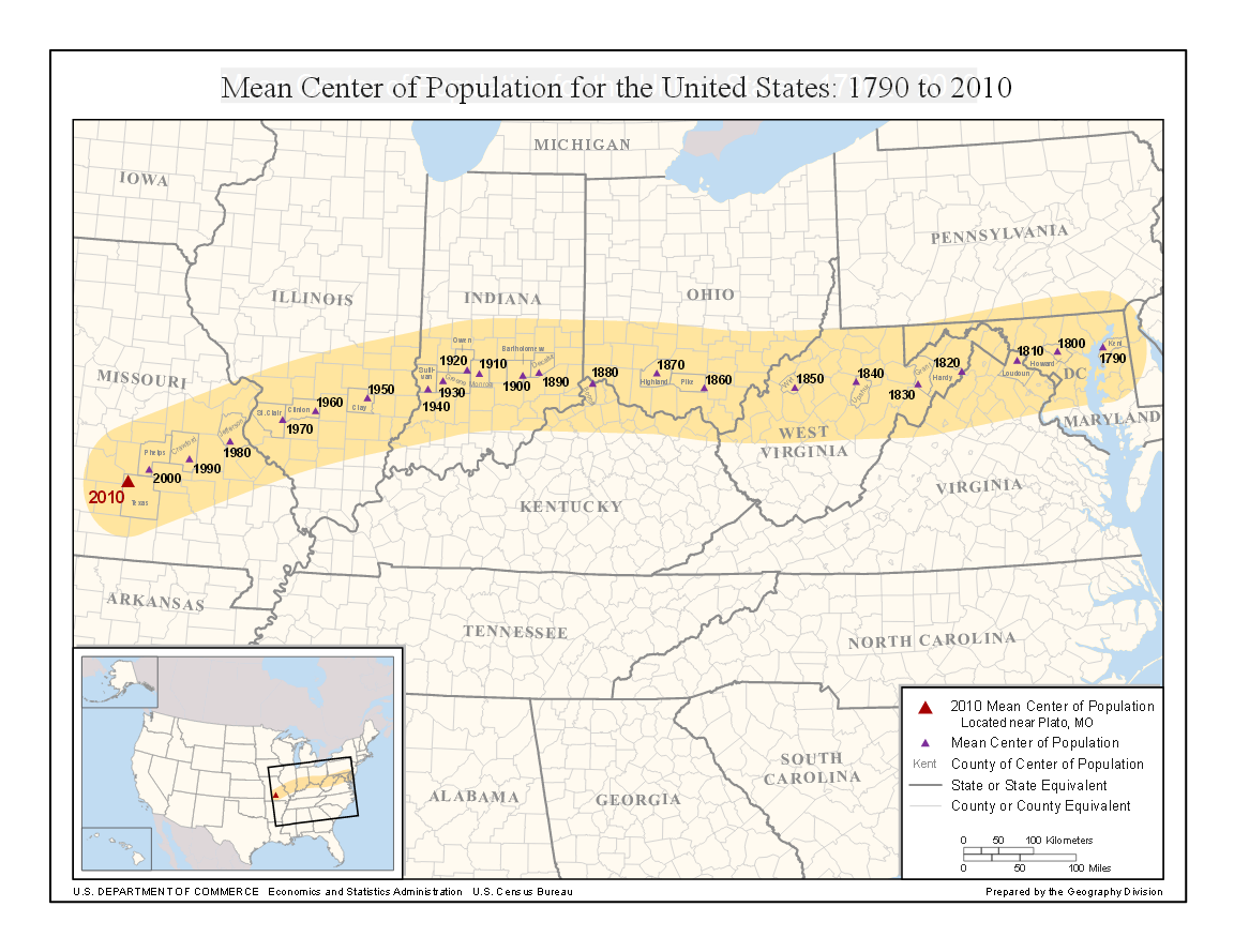
As previously mentioned, the population centre has been shifting over the years. The first population centre was Baltimore, Maryland, in 1870. Since then, it has moved West and to the South, with the current population centre being located in Hartville, Missouri, making this the fifth time in history that the population centre has landed in Missouri. In 2000 it was in Edgar Springs, Missouri. During the second half of the 20th century, the population centre has moved about 50 miles west every ten years.
Mean Population Centre of the U.S. from 1970-2010
Mathematical processes such as looking at average rates of change can help us analyse this movement and understand how it is studied. For example, we can use maths to express the approximate position of the population centre as a function of time since 2000. Let’s assume 
 = 5t")

Straight-line distance from Baltimore, MD to Edgar Springs, MO
We can also use similar processes to determine whether the population centre could have been moving at roughly the same rate for the last two centuries. If the population centre had been moving at a rate of 5 miles per year consistently for the past two centuries, the total distance covered would be

This implies that the movement rate has remained relatively consistent, as it matches the distance between Baltimore and Edgar Springs.
Mathematical formulas and calculations such as these are important for a variety of reasons. Having dating such as the population centre of the United States is important because it provides us with important information about the current state and trends within the United States. This data helps policymakers, urban planners, and researchers in making informed decisions regarding infrastructure development, resource allocation, and social programs. Understanding population distribution patterns is necessary in order to for addressing the needs and challenges of an ever-changing country.
Sources
“Geographic Centers of Population: United States.” Census.gov, U.S. Census Bureau, 2021, www.census.gov/geographies/reference-files/time-series/geo/centers-population/united-states.html.
“2020 Census Reveals the United States Is a Much Different Nation.” Census.gov, U.S. Census Bureau, 2021, www.census.gov/newsroom/press-kits/2021/2020-center-of-population.html.
“Center of Population.” NOAA’s National Ocean Service, U.S. Department of Commerce, 22 Mar. 2022, oceanservice.noaa.gov/news/mar22/center-population.html.
Hughes-Hallett, D., Gleason, A. M., Lock, P. F., Flath, D. E., et al. Applied Calculus. 5th ed., Wiley, 2013.
Hi Kaity! It was super interesting to read about the population center, because I have honestly never heard of this concept even once before, and you explained it super clearly. I wonder what aspects influence the changes in position of the center the most– maybe the job economy, or different geographic areas? It’s funny that the center has ended up in Missouri so many times.
Hi Kaity! Population dynamics are a topic very prevalent in today’s politics and society. It was cool to learn about the mathematics behind the population center. Average rates of change can help us understand and measure this population center. I found your examples to be very interesting and descriptive (detailing how the population center between Baltimore and Edgar Springs has moved at a rate of 5 miles per year for 200 years). I never really knew about this phenomena until reading your post! As mentioned by Leah, I wonder how this change affects society, the economy, and resource production. I think it may tie into my topic of resource distribution in some ways (If the population center is moving, how does this affect the distribution of resources across the population?) In summary, great job!
Hey Kaity! Great post I really found this topic interesting and honestly didn’t even know this kind of analysis existed. I thought you brought the reader each concept gradually and effectively, beginning with population center’s definition and progressing into how we can use average rates of change to track how this population may fluctuate over time. I additionally appreciated the pictures / graphics you used to show where the population center lies on an American map. That was both informative and helped me visualize this concept more effectively!