


NEW: For shared risk proposals with more than 10 co-Investigators, these may be listed on a separate page that does not count toward the limit of 2 pages + 1 page for Figures & References. If this option is chosen, this extra page should be in the form of a simple list containing the name and institutional affiliation of each co-Investigator.
The BLAST collaboration intends to allocate 25% of the total available science time during our December 2018 flight to observing proposals from the astronomical community. Note that these will be shared-risk proposals – observations will only be carried out if warranted by the in-flight performance characteristics of BLAST-TNG, as determined by the BLAST team after launch. Observations, data reduction, and production of science-quality maps will be carried out by the BLAST team on a best effort basis and with the understanding that BLAST team members will be co-authors on publications resulting from the observations.
BLAST-TNG observes simultaneously in three frequency bands centered at 250, 350 and 500 μm. An estimate for the mapping speed and resolution at each frequency band is given below. Assuming a 25-day flight, we expect to allocate approximately 125 hours of time to shared-risk proposals received from the astronomical community.
CALL FOR PROPOSALS
blastproposalquestions@northwestern.edu
blastsubmit@northwestern.edu
BLAST-TNG Shared Risk Proposal Information (PDF)
Schedule for the BLAST-TNG shared-risk observation program:
JULY 24th 2018: Call for shared risk proposals
AUGUST 31st 2018: Notice of Intent Due
SEPTEMBER 21st 2018 (6PM EDT): Proposal Deadline
NOVEMBER 1st 2018: Proposal Evaluations Released
DECEMBER 2018: Launch of BLAST-TNG from McMurdo Station, Antarctica
EARLY 2020: First-look maps released to shared-risk PIs
EARLY 2021: Science-quality maps released to shared-risk PIs
TWO YEARS AFTER DELIVERY OF SCIENCE QUALITY MAPS: Shared-risk program data becomes public
Expected Mapping Speed
Based on our experience with BLASTPol we expect the following mapping speeds.
| Central Wavelength [μm] | 250 | 350 | 500 |
| Beam FWHM [‘’] | 30 | 41 | 59 |
| σI (for a 1.0 deg2 map observed for 5 hours) [MJy Str-1] | 0.33 | 0.200 | 0.075 |
| Imin (σp =0.5%, time=5 hours, map area= 1.0 deg2)
[MJy Str-1] |
188.7 | 113.4 | 42.4 |
Note: For a given map area and time observing the map (in the table we chose an area of 1.0deg2) Imin gives the minimum dust intensity for which the error in fractional polarization (σp) is less than 0.5%. For more details on BLAST-TNG sensitivity calculations and mapping strategy see the above Shared Risk Proposal Information (PDF) document.
Sky Visiblity from Antarctica
BLAST-TNG is restricted to observe with the telescope elevation between about 20 to 55 degrees. The allowed range of telescope azimuth is set by the requirement that radiation from the sun does not reach the primary mirror. The region of the sky available to BLAST-TNG therefore will change over the course of the flight. Changes in latitude of the telescope as the balloon travels around Antarctica will also affect visibility.

Expected visibility for BLAST-TNG on January 18th 2019 at a latitude of -77.5 degrees (approximately the same as McMurdo Station). The visibility represents the total number of hours that each map pixel is visible in a 24 hour period. The background image shows the Galactic Plane dust distribution from the SFD models.
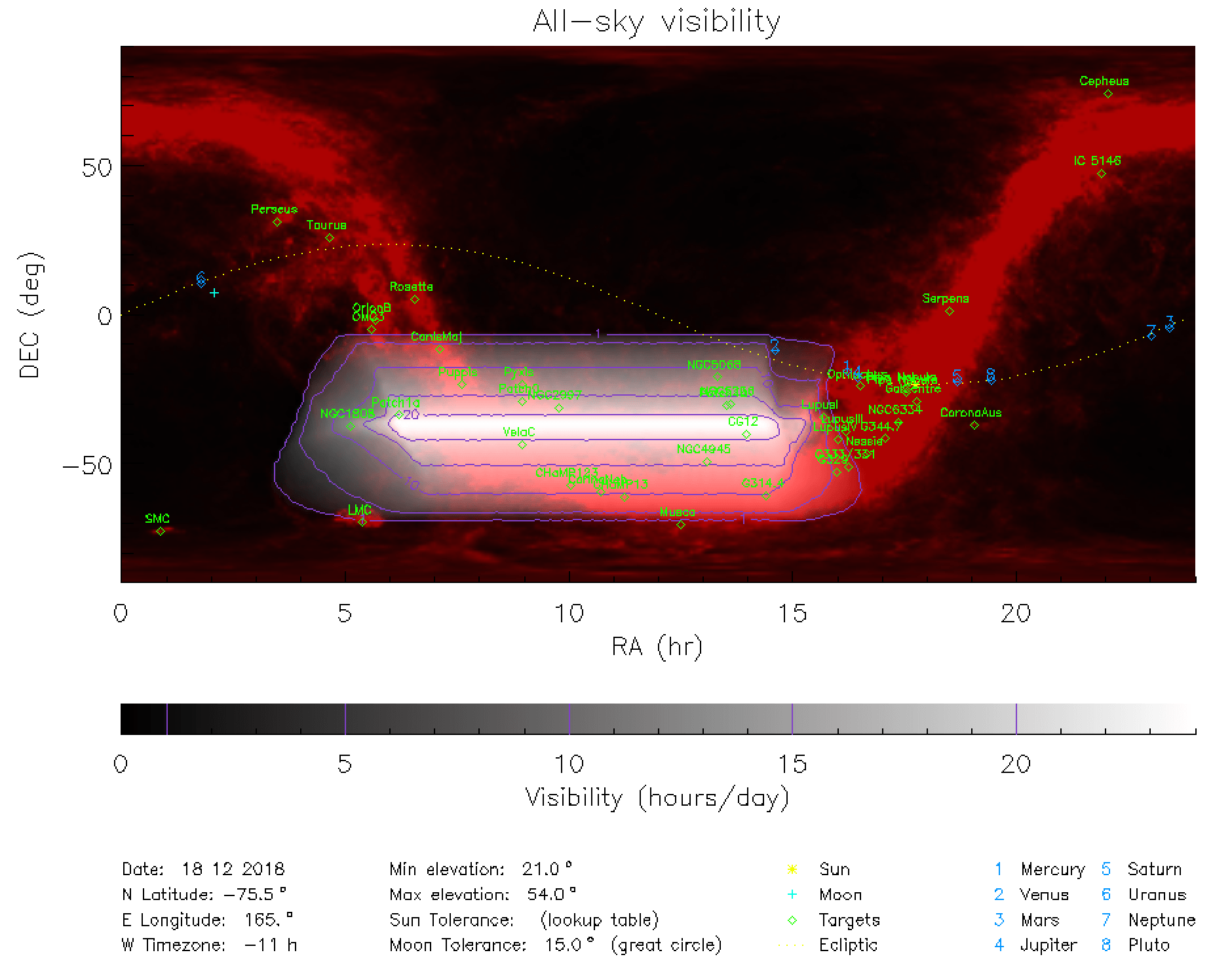
Expected visibility for BLAST-TNG on December 18th 2018 at a latitude of -77.5 degrees (approximately the same as McMurdo Station). The visibility represents the total number of hours that each map pixel is visible in a 24 hour period. The background image shows the Galactic Plane dust distribution from the SFD models.
Reserved Objects List
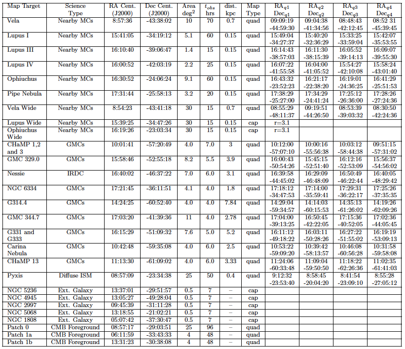
Reserved Objects List for the BLAST-TNG flight. Click to enlarge.
Shared-risk proposers may not propose to observe targets within these areas unless their particular science goal requires much better sensitivity or more sky coverage. Any maps made of these targets will be made publicly available within a year after first look papers are published. We indicate the map size and in the case of quadrilateral maps the corners of the region that will be observed (if no corner coordinates are given then the region is a square oriented parallel to the Galactic coordinate system). Cap scans indicate circular scan areas.
