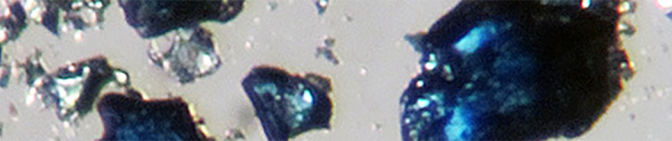
Ringwoodite blue crystal ~ 150 micrometers wide. Microphotograph taken at the University of Hawaii of a specimen grown in Bayreuth, Germany. Author: Joseph Smyth . Header image: The blue ringwoodite material.Steve Jacobsen, 2014.
Ringwoodite is the most common mineral phase in the lower transition zone of the Earth’s mantle, at depths of 525 to 660 km. This ringwoodite crystal contains about 1% water. If the whole ringwoodite of the mantle contains this amount of water, it is estimated that there is almost three times as much water in the mantle as in all the oceans combined!
Cross section of the planet Earth ( Pearson et al, 2014 ). Credit image: Kathy Mather.
At closer look into the cross section of the planet Earth we can identify the transition zone that separates the upper mantle from the lower mantle. Right there, diamonds are formed and together with the included ringwoodite -which in turn traps the water molecules- both minerals continue their journey to the surface through volcanic activity.
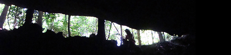
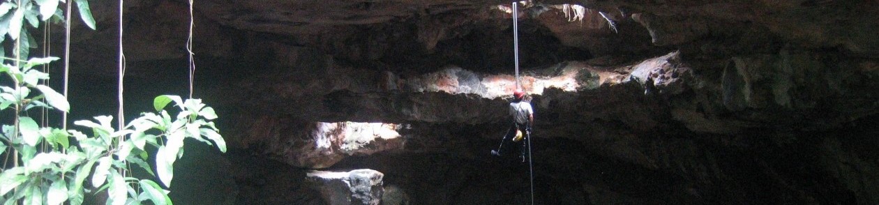
The first discovery on Earth of ringwoodite inside a diamond was made by an international team led by the University of Alberta and could indicate the presence of large amounts of water between 410 and 660 km below the Earth’s surface.
The diamond found in Brazil originated approximately 550 km below the earth’s surface, where large masses of water can accumulate by subduction and by the advance and recycling of the ocean floor towards the transition zone. The results of these investigations were published in 2014 by Pearson et al. (2014) in the journal Nature.
Schematic model of subduction of oceanic crust altered by seawater and the infiltration of brines into the base of the deep continental root beneath NWT, Canada, to make fluid-rich diamonds.
“What we appear to be finding more and more is that the standard model that used to be around—diamonds are only formed in very ancient times, 3.5 billion years ago, by a very specific process—is not true,” says Pearson. “There are more processes that form diamonds at a whole range of different times than we thought possible.”
Cross section of the Earth’s interior.
Simultaneously, the study by Steve Jacobsen and Brandon Schmandt used seismic waves to find magma generated at the base of the transition zone, around 600 km deep. Dehydration melting at those conditions, observed in the study’s high-pressure experiments, also suggests the transition zone may contain oceans worth of H2O dissolved in high-pressure rock. The findings alter previous assumptions about the Earth’s composition.
The part of the hydrology called oceanography (division is arbitrary) studies the ocean and other water bodies from the aquatic point of view. It is closely related to at least four basic areas: physics, chemistry, biology and geology, as well as limnology, meteorology and glaciology, which confers a unique multidisciplinary flavor.
Spheres. Modified from: Brian J. Skinner and Barbara W. Murck, 2011. The Blue Planet: An Introduction to Earth System Science. 3rd Edition. John Wiley & Sons.
However, in our planet the ocean and aquatic systems are integrated into one, constantly interacting and exchanging materials with other spheres. Depending on the type of processes that we want to understand, it also does change the way of studying them. Although the analytical approach, to separate the parts of reality to study it is very useful, for the deep understanding of it is necessary to perform the synthesis, that is, the reintegration of information.
In contrast, the term “aquatic biogeochemistry” refers to the physical, biological and geological aspects that are inevitably associated with chemical processes in the bodies of water on Earth. It emphasizes the biogeochemicalcycles of the elements, that is, their exchange between spheres and their physical and chemical transformations along the way. In addition, it encompasses all types of aquatic systems other than the ocean that exist in our planet such as rivers, lakes, reservoirs, ponds, estuaries, fjords, cenotes, coastal lagoons, coral reefs, mangrove swamps, wetlands, and underground deposits.
A molecule of water at the bottom of Lake Chapala may eventually fall as rain on the Tuxtlas in Veracruz. It may be carried by the Papaloapan River to the Gulf of Mexico, where it will later drain into the Atlantic Ocean through the Labrador current and probably continue its way to the north, near Iceland where, after evaporating and precipitating in the form of snow, it becomes part of a glacier for thousands of years. Other molecules, are dragged to great depths under the terrestrial crust, where they are mixed with the magma and come back in the form of vapor or within mineral inclusions in diamonds after a volcanic eruption. One of those molecules can be carried by the wind, to once again precipitate – after millions of years – in the lake of Chapala (if it’s that still exists of course, although it would surely have moved a few kilometers away).
Water on Earth
One of the central questions of hydrology is: What is the origin of water on Earth? Where did it come from? All the water currently present on the surface of the Earth comes from its interior (although there is discussion in this, since it was formerly thought that it came from comets that have collided with our planet and a minimum amount could have come from this source indeed), which has been progressively liberating since Earth’s formation about 4,600 million years ago. Although this process is still ongoing, it is estimated that the water that formed the current oceans and atmosphere had already surfaced from the interior about 2,500 million years ago, and that the current degassing rate is much lower.
A drop in the Ocean
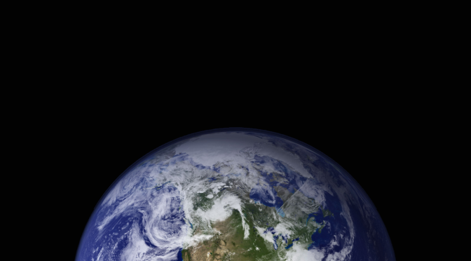
Viewed from outer space, Earth has been called the Blue Planet. But if you could pull all the water in the ocean, the atmosphere, groundwater and surface water into a ball, it would measure only about 950 miles (1,500 kilometers) in diameter (the large sphere). Only about 3 percent of the world’s water is fresh (the mid-sized sphere); and of that, only one-third is easily accessible to humans (the small sphere).
The difference with other planets, in terms of water content, would be because they could not retain it on its surface and the water escaped to the space. More recently, with the discovery of a diamond formed 600 km deep in the transition zone of the Earth’s mantle, which contains an inclusion of the mineral ringwoodite and several water molecules (this mineral can contain between 1-3% water by weight) strengthened the hypothesis that water from lakes, rivers and oceans came from the interior of the planet. If the entire ringwoodite of the mantle contains this amount of water, it is estimated that there is almost three times as much deep water in the mantle as in all the oceans combined. This also implies that the hydrological cycle penetrates hundreds of kilometers below the surface of the Earth, with residence times in depth on a scale of millions of years.
The first Earth discovery of ringwoodite was made by an international team led by the University of Alberta and could indicate the presence of large amounts of water between 400 and 700 km below the Earth’s surface.
One of the distinctive features of the northern Yucatán Peninsula is its almost flat topography, lacking valleys or mountains, and altitudes that barely exceeds 30 meters. The soil type consists mainly of limestone, or saskab (Maya word for “white soil”), which contains calcium and magnesium carbonates that are slightly soluble in water.
Millions of years ago the Peninsula was very different from how we know it today, as it has undergone radical modifications due to climate and sea level changes on the planet. An example of these changes was during theLast Glacial Maximumat the peak of the Ice Age – about 22,000 years ago – when the sea level was 120 meters below its current level, and many of the cenotes in which we can snorkel and dive today were dry. Since then, the level of the sea has been progressively increasing more or less gradually and many caves were flooded.
The portion that we inhabit today above sea level of the Yucatan Peninsula, is only the exposed part of the carbonate platform that was steadily growing from the seabed by accumulation of millions of skeletons of different marine organisms that use calcium carbonate to form their bones, shells, spicules and other parts of the body. Upon dying, they deposit on the bottom surface to compact and harden together with fine clays over millions of years. It is important to recognize that the growth of the platform happens through the deposition of biogenic carbonate, sourcing from living organisms, and moreover, that it involves a process that necessarily happens underwater across the submerged areas.
Figure 1. The Yucatan Peninsula is the portion that we observe above sea level of the Yucatan Platform, which has a much larger area. In the Riviera Maya on the eastern coast of Quintana Roo, the change in depth is very abrupt compared to northern Yucatan and the Campeche Sound towards the Gulf of Mexico, where the shallow platform extends for several kilometers. Bathymetry: Secretaría General de Oceanografía, Secretaría de Marina, Mexico (YUCATAN ’85). SRTM model of elevation: NASA (2000).
Sea level has changed position several times during different glacial periods; therefore, the growing Peninsula has not really “emerged from the sea” but has been exposed and submerged by the ocean on several occasions. However, it is recognized that every time a glacial cycle begins, the Peninsula effectively “emerges”, since the water of the oceans accumulates in the form of ice at the poles of the planet and the sea level drops, exposing a greater surface and increasing the coastline extent.
Figure 2. Changes in sea level during the last 800,000 years. The present is on the right. LFI (Last Full Interglacial); LGM (Last Glacial Maximum). Data from Siddall et al. (2003).
Currently, the term cenote is used to designate any underground space filled with water that contains an opening to the outside. The Maya people, who not only had knowledge of these manifestations of the land but used them daily as a source of water and farming, called them ts’ono’ot or d’zonot, which means “water deposit”. The freshwater supply in the Yucatan Peninsula has been and continues to be a serious problem for its inhabitants. Although more or less abundant rains fall during four months, the period of drought is usually severe and can last up to six months in some years. On the other hand, the calcareous geological origin causes that water is hardly conserved on the surface. For this reason, cenotes and cave systems constitute a primordial source of water for the region.
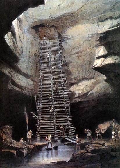
Figure 3. Cenote Xtacumbilxunan, in Bolonchén (‘nine wells of water’) Campeche. This town escaped the cholera epidemic of 1833. The only source of fresh water flows in the depths beneath thick layers of limestone. Lithograph by H Warren. Image published in “Views of Ancient Monuments in Central America, Chiapas and Yucatan” – Frederick Catherwood (1844).
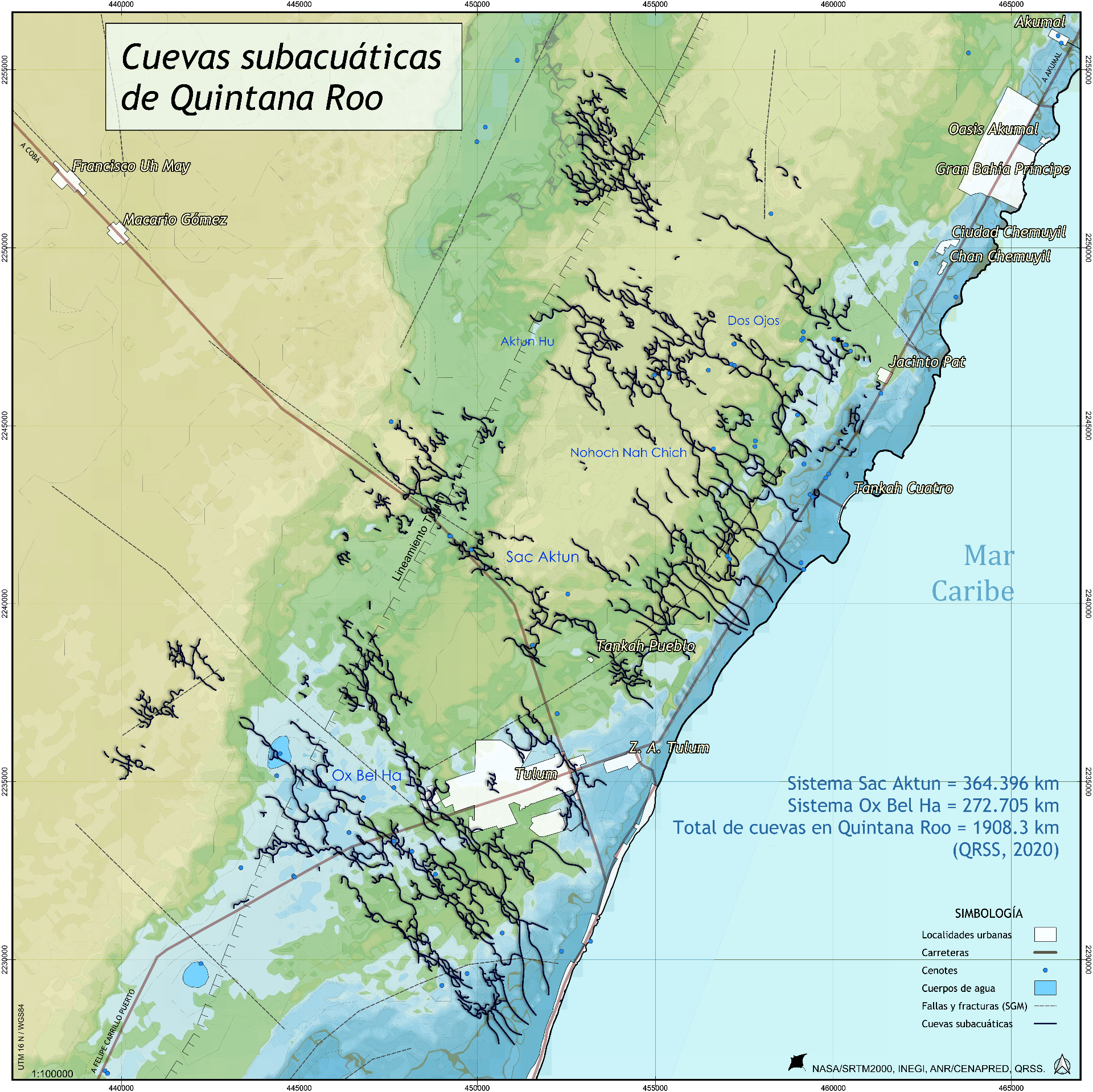
In the present, although certain practices of veneration subsist, it is clear that it’s meaning is far from what it was for the ancient Maya. Nowadays, its value is mainly associated with tourism. It is known that Quintana Roo has several of the largest cave systems in the world. Recent explorations carried out by divers’ teams have uncovered hundreds of kilometers of underground conduits (it was recently announced a connection between two of the most extensive flooded cave systems on Earth —Sac Actun and Dos Ojos— now forming the world’s largest known flooded cave, with a length of 353 km, moving Ox Bel Ha to the second place).
Figure 4. Tulum metropolitan area is located between two extensive systems of underwater caves called Sac Aktun and Ox Bel Ha. Data: NASA/SRTM, INEGI, QRSS (2020)
Moreover, there is also a large number of dry caves of considerable length. We cannot ignore their existence if we want to coexist with them.
Sneaking into a cave is an unforgettable experience. The caves tell us about geology, biochemistry, paleontology, archeology, and history. Caves motivate us to know them and to think about their future.
How were cenotes formed?
Speleogenesis is the word used in speleology and geology to describe the mechanism of formation of all kinds of caverns and caves. One of the most accepted hypotheses about the origin of caves, cavities, sinkholes, depressions and cenotes, proposes a sequence of steps in a process called karstification, which consists of the combination of at least three mechanisms: dissolution, collapse and recrystallization of the limestone.
1) In the first step, the rock is dissolved by rainwater acidified by absorption of the carbon dioxide (CO2) both from the air, as well as from the decomposition of organic matter in the soil (leaves, branches, dead animals, bacteria). When mixed with salt water increases its corrosive power. Where the deep salty and superficial layers of fresh water meet, called halocline, is where the greatest dissolution of limestone happens, forming an extensive network of conducts, caves and caverns. Cave divers can see that generally just above the halocline the caves are generally wider, a sign that the dissolution is greater at that depth and that is a continuous developing process, still happening.
Acidified rainwater dissolves calcium carbonate from limestone more easily and forms calcium bicarbonate, a much more soluble compound. Another type of solution, but of biological origin, is that which occurs inside some deep cenotes where specialized bacteria decompose the organic matter producing hydrogen sulfide (H2S), a powerful corrosive gas, and when dissolved and concentrated on the surface of the halocline, it is observed in the form of a “smokey cloud” that is very toxic for oxygen-breathing organisms like us. Upon contact with the surface layer, which may contain little amounts of dissolved oxygen, hydrogen sulfide is transformed into sulfuric acid (H2SO4), also a strong and corrosive acid.Figure 6. Karstification mechanisms. Source: McColl et al. (2005). Geological Survey of Canada .
2) In the second mechanism, when the sea level has dropped during glacial periods, the hydraulic head of the aquifer, the freshwater lens, also drops leaving submerged caves now full of air where, lacking support, different sections of the roof can collapse forming a sinkhole or cenote. At the end of the glacial period, the poles thawed and sea level rose and many passages and caves were flooded again.
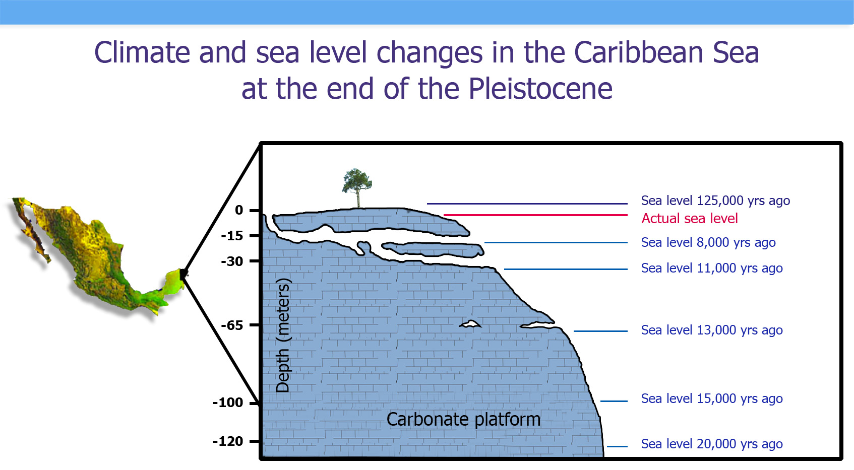
Figure 7. Changes in sea level at the end of the Pleistocene epoch, which began 2.5 million years ago setting up the modern glacial periods. When the sea level changes, the position of the halocline also changes and the cave systems begin to form and extend. Modified by González-González et al (2008) and Blanchon & Shaw (1995).
3) Finally, the third step associated with the process of karstification is responsible for the formation of stalactites, stalagmites, columns and other speleothems, by accumulation of dissolved material sourced by the first step. Degassing is also involved in the formation of speleothems: Water filters through the rocks and enters the cave environment, very different from that of the outside, and expulsion of CO2 from water causes calcium carbonate precipitation. In the case of flooded caves, this process no longer happens. The degree of karstification depends on factors that operate with different spatial and temporal scale, which allows a great variety of shapes and decorations in the cave systems.
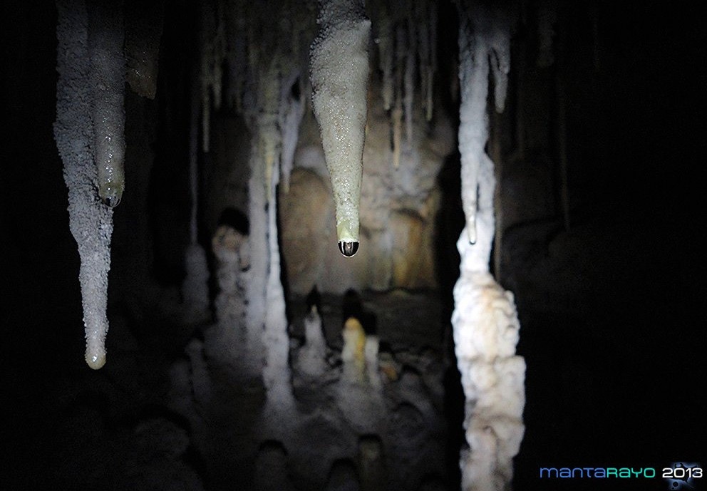
Figure 8. Drop of water with dissolved calcium carbonate, suspended from the central channel of a stalactite. Quintana Roo / Personal archive. EMR, 2015.
Having these mechanisms in mind, we can say that the formation of some cenotes is generated through a sequence of events: first of all, a network of passages, conduits and cave system is formed by water carving its way out to the ocean dissolving the carbonate rock. This flooded cave can form a cavern-type cenote due to partial subsidence of the roof. This process advances from above, by infiltration of the rain and from below, by underground circulation. Then, the entire roof collapses forming a cylindrical cenote (although many cylindrical cenotes can have a bottom-top hypogenic origin, keep reading below); if sediments and debris interrupt the flow, a body of stagnant water called aguada, is formed. However, scientists prefer to classify caves, sinkholes and cenotes by their mechanisms of formation -their espeleogenesis- rather than by their present morphology.
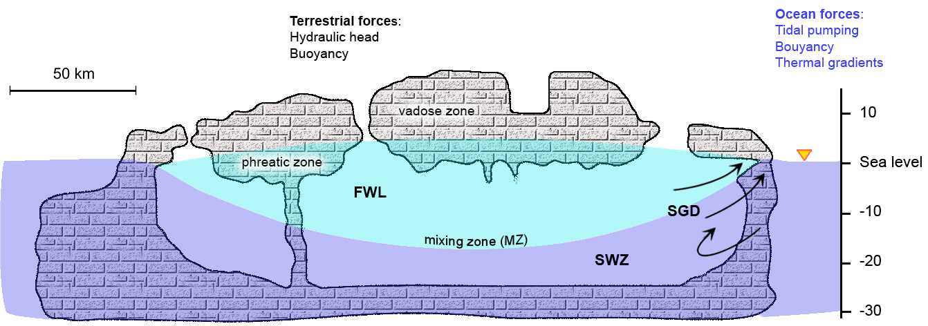
The halocline stratifies the cenote: it functions as a physical barrier that isolates the layer of fresh water from the deep saline waters. In the coastal sinkholes, the deep marine layer is not always really stagnant, but can circulate driven by tides and storms through channels connected to the sea (a very clear case is the discharge from Cenote Manatí to the shore in Tankah). We also observe freshwater springs called “ojos de agua” discharging fresh water to the ocean and exchanging salt water along the reef lagoon in Puerto Morelos and on the shallow water beaches south of Tulum.
Figure 9. Diagram of the Yucatan Peninsula, where the groundwater is separated into two layers of different salinity and density: the shallow freshwater lens and the deep saline intrusion that filters through the rock. The mixing zone between the two layers is called halocline. SGD: Submarine Groundwater Discharge surfaces creating freshwater springs at the adjacent coastal ocean. EMR, 2015.
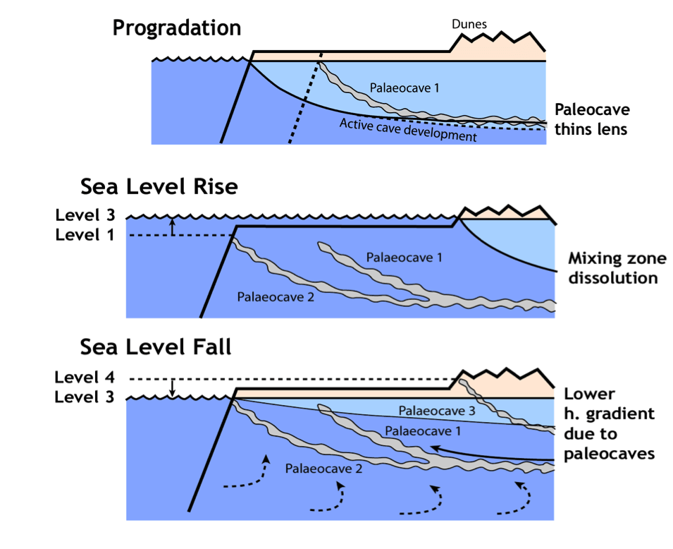
The largest dissolution occurs in the halocline zone, the contact between fresh and salt water, which rises or falls depending on the sea level. For this reason there are different levels of horizontal caves (for example, in the “Dos Pisos” system). By changing the sea level, the halocline moves and begins to dissolve the rock at a different depth, thus beginning another “level” of passages.
Figure 9. Mechanism of formation of different levels of caves: initiates the development of the cave at the depth of the halocline;as the sea level rises, the caves develop higher up, near the beach dunes;When the sea level decreases, these caves remain dry and the lower ones are submerged.The hydraulic gradient decreases and the freshwater lens thins.
Cenotes are complex aquatic systems generated by the dissolution of carbonates and other minerals in the rock, so in geology they are also called dissolution lakes, although in reality some cenotes are more similar to rivers or estuaries rather than lakes, since they have connections to underground ramified streams that favor the circulation of water. These types of aquatic systems, where fresh and salt water coexist, are called anchialine.
The intermittent collapses along the different cave systems of the Peninsula create open windows towards the surface where we can enter and dive submerged conduits and passages. Generally the cenotes in the eastern part of Quintana Roo are formed by the collapse of cave systems formed over very long periods of time, when the depth of the halocline has remained for a long time more or less in the same position, extending horizontally. Popular cavern and cave diving destinations in the Riviera Maya such as Sistema Sac Aktun (recently connected to Sistema Dos Ojos), Sistema Ponderosa, and Sistema Ox Bel Ha belong to this category.
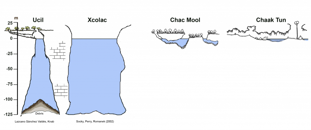
Figure 10. Comparison of different types of cenotes with different formation mechanisms. Left: Pit-cenotes that predominate in the center of the Peninsula and along the Ring of Cenotes. In them, deep flowing water circulation is probably involved, favoring the dissolution of the rock from below advancing upwards. Right: Morphology of the most common cenotes found in the “Riviera Maya”, the eastern coast of Quintana Roo. These cenotes are the entrance to systems of shallower caves normally presenting wide galleries and branched passages. EMR, 2015.
Another type of cenotes, more common in the center of the Peninsula, like those located at the Ring of Cenotes, are the so called pit-cenotes (although there are some pit-cenotes in Quintana Roo, for example the Blue Abyss or The Pit, which exceed 120 meters deep) where its formation mechanism surely involves deep water circulation, growing from the bottom up, a process acting from below.
Datos: NASA/INEGI/SEDUMA
Figure 11. Some of the cenotes of the “Ring of Cenotes” in the northwest part of the Yucatan Peninsula. Chicxulub shows the approximate location of the center of the crater created by the impact of the meteorite 66 million years ago. EMR (2018).
To achieve a sustainable use of these systems, it would be ideally to acquire a comprehensive understanding of cenotes, caves, groundwater circulation and its interaction with the rocks that form the aquifer, and the influence of oceanic tides. It is also necessary to evaluate the impact of urban areas and the possible causes of pollution of the only source of fresh water in that area, which is precisely groundwater. Research efforts on study and conservation of the underground network of conduits must occur by convergence between environmental sciences, water sciences, earth sciences, biological sciences, joining forces with local communities, efficient exploitation of resources and, of course, exploration and sustainable use by cave diving.
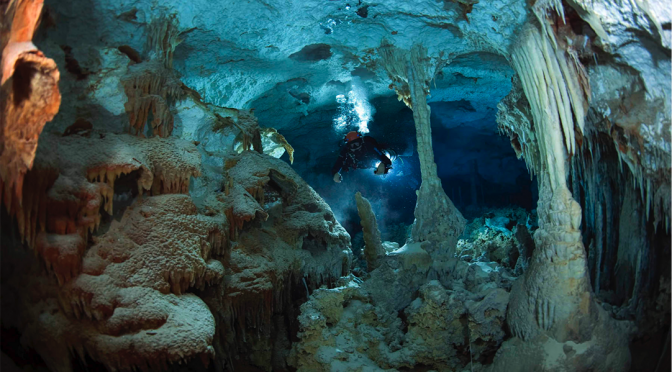
An award-winner picture from Nature’s The best science images of the year 2017 shows a cave diver penetrating the underground aquatic systems in the eastern coast of the Yucatan Peninsula. We can see dead trees resting quietly at the bottom.
ORANGE ABYSS: Heavy rains and run-off from surrounding forests give this underwater cavern — the Cenote Aktun Ha (Carwash) off Tulum on Mexico’s Caribbean coast — its eerie tannic glow.
Credit: Tom St George/Caters News
Suggested way to quote this article:
Monroy-Ríos E (2017) Speleogenesis: How were caves and cenotes formed?
Karst Geochemistry and Hydrogeology – Personal blog. Published on Dec 26, 2017. Accessed: [dd / mm / yy]. https://sites.northwestern.edu/monroyrios/2017/12/26/speleogenesis/


 Credit: University of Alberta. Source: phys.org.
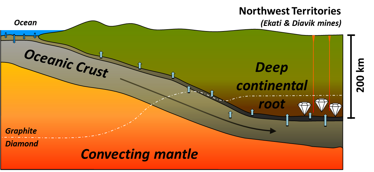


; LGM (Last Glacial Maximum-Último Máximo Glaciar).")